Geography uses an inquiry approach to assist students to make meaning of their world.
What is geographical inquiry?
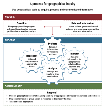
Questions shape geographical inquiries. Geographical data and information from primary and secondary sources is collected in response to the questions. This data and information is represented, evaluated, interpreted and analysed to support conclusions.
Students use age appropriate geographical terminology and tools to accurately represent data and information in a range of forms. They construct graphic representations and communicate information in response to the questions. Often an active citizenship response is also required.
It is important to note that a geographical inquiry can be applied at a range of scales, from a short in-class or fieldwork activity right through to an entire unit of learning.
|
|
View the presentation Geographical inquiry (.ppsx 2MB). |
|
Each focus area in the syllabus provides 3–4 key inquiry questions. Formulate additional inquiry questions to clarify and support these questions and which relate to the chosen case study.
|
 |
What are the features of geographical questions?
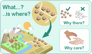
Geography is distinguished by the kinds of questions it asks―the ‘What…?’, ‘…is where?’, ‘Why there?’ and ‘Why care?’ of an issue.
Successful geographical inquiry involves the willingness to ask, speculate on, and answer geographical questions about why things are, where they are, and how they got there.
Geographical questions deal with:
-
location and extent (reference the concepts of place and scale)
-
distribution and pattern (reference the concepts of space and interconnection)
-
spatial association and interaction (reference the concepts of environment and interconnection)
-
spatial change (reference the concepts of change and sustainability).
|
|
Read ‘Framing the questions’ |
|
|
Activity 9: Geographical questions Choose a syllabus content dot point within the stage you selected. What geographical questions could be used to undertake a geographical inquiry for this content? You may need to refer to a case study. Record your responses in your Activity booklet. |
Acquiring data and information requires the location, collection, gathering and recording of primary and secondary geographical data and information suitable for the age and stage of learning, referenced to the syllabus. Determine the data that needs to be collected to answer the inquiry questions.
Identify the geographical tools students will need to use to collect primary and secondary data and information. Fieldwork is a geographical tool which is intrinsic to the discipline. A variety of data and information can be located, collected, gathered and recorded using appropriate fieldwork techniques.
-
Primary data and information is collected in the field, such as measurements, photos, drawings, and interview responses gathered first hand.
-
Secondary data and information is material sourced from books, magazines, published maps and internet searches. Data includes various maps, recorded weather information, population statistics. Secondary data can be gathered prior to or after the collection of primary data. This data and information needs to add value to the primary data collected.
The terms ‘primary data’, ‘primary information’, ‘secondary data’ and ‘secondary information’ should not be used interchangeably. They should be assigned different meanings.
|
|
Activity 10: Acquire data and information What do you mean when you use the terms ‘primary data’, ‘secondary data’, ‘primary information’ and ‘secondary information’ in a geographical context? What will your students infer from your use of these terms in geography lessons? Create a personal glossary of these terms in your Activity booklet to ensure your consistent use of them. Compare your responses with those of colleagues. |
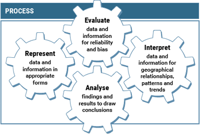
Processing geographical data and information requires the manipulation and interpretation of collected data and information through the use of geographical skills and tools.
Teachers need to model how geographers examine a wide range of data and information. Adequate time should be allocated to the processes of representing, evaluating, interpreting and analysing the data and information that is collected and recorded from a variety of primary and secondary sources. Students need support to evaluate data and information for reliability and bias.
Geographical tools assist in making sense of the data and information gathered using:
-
a range of literacy and numeracy skills
-
maps, tables, graphs and diagrams.
These processing strategies support the development of geographical knowledge.
The following table provides a brief explanation about how to process the data and information required to develop a geographical inquiry. In practice, this is an iterative process as illustrated in the diagram above.
| Process | Process Explanation | Examples |
|---|---|---|
|
Organise and represent geographical data and information |
Data is systematically organised, classified and translated into visual forms, and effectively arranged using design, colour, graphs, scale, tables. |
|
|
Interpret geographical data and information |
Interpret a variety of information to enable the emergence of meaningful patterns, processes, relationships, similarities, differences and trends. |
|
|
Evaluate the geographical data and information |
Evaluate data and information systematically for reliability and bias. Evaluate the way the data and information is organised to enhance understanding. |
Interrogate for validity.
|
|
Analyse findings and results. Draw conclusions. |
Reference the evidence to shape conclusions as a response to the geographical questions posed. |
Develop conclusions based on the data collected, organised and analysed. |
|
|
Activity 11: ‘5 Seasons’ View a short clip from the 2004 documentary 5 Seasons (clip title, Everything has a cycle). List the data and information conveyed in this clip and provided in the education notes that accompany it. List additional data and information required to respond to ONE of the following inquiry questions:
Determine and record the specific inquiry processes to represent, evaluate, interpret and analyse the information. |

Communicating the results of a geographical inquiry requires presenting a ‘discussion’ in response to the inquiry question(s) that shaped the process of investigation. Students discuss their evidence-based claims resulting from the inquiry findings. The communication can consider possible futures, a probable future and a preferred future which provide a solution to the geographical problems they have investigated.

© A Southwell
Communicating the findings of a geographical inquiry can take many forms. The type of communication should reflect the age and stage of learning as well as provide a mode that is meaningful and appropriate for the processed data and information that needs to be conveyed.
Read several examples of communication responses.
Geography also takes students beyond communicating their knowledge, understanding and skills. It can empower them to participate effectively in maintaining and improving the quality of their society and environment.
It is hoped that students then have the opportunity to undertake appropriate action in response to these geographical investigations. The action should relate to the best possible outcome in support of the preferred future.


