The deliverable for this course is an implementation plan for one focus area of the Geography K–10 Syllabus.
This section will assist you in completing your implementation plan. For each content heading in your focus area, you will need to complete the following columns:
-
Case study
-
Inquiry question(s)
-
Learning experiences
-
Tools (K–6) or Tools/Skills/Concepts (7–10)
-
When.
Note: The geography K–10 teaching and learning frameworks downloaded in the previous section may be of considerable assistance in creating your implementation plan. Participants are encouraged to refer to the relevant framework(s) when completing each column.
|
|
Download the Geography K–10 planning template (.docx 164kB) if you haven’t already. This document contains templates for all fifteen focus areas in the Geography K–10 Syllabus. It does not include learning across the curriculum icons. Print out an A3 copy of the template for your chosen focus area. Hint: The document is in A4, so scale the printing to A3. |
© A Southwell
The content in each focus area is taught through a series of inquiries using the geographical inquiry process. The organisation of content into inquiries is done concurrently with choosing case studies.
Each content heading will usually necessitate its own inquiry and case study. A few observations:
-
Units of learning may include more than one inquiry. The teaching and learning frameworks, for example, contain up to four inquiries.
-
Each inquiry will usually involve at least one case study.
-
Case studies need to be contemporary and relevant to students.
-
The starting point is:
one content heading = one inquiry = one case study
The planning template layout reflects this assumption. In practice, it will be more complicated. Content headings can be split or combined, and inquiries may require more than one case study (for example, if two settings are being compared).
Contemporary case studies need to be selected that allow students to engage in geographical inquiries to cover the syllabus content.
Example Box 1
The Stage 1 focus area Features of Places has three content headings. The third contains the following:
| Content heading | Content |
|---|---|
|
How places are organised |
Students:
|
As suggested in the content itself, a Stage 1 class might undertake an inquiry using their local school environment as the case study. Alternatively, a local recreation area may provide a suitable case study.
Example Box 2
The first content heading for the Stage 3 focus area Factors that Shape Places states the following:
| Content heading | Content |
|---|---|
|
Factors that change environments |
Students:
|
This content heading clearly requires two case studies, one in Australia and one in another country. These two case studies can be paired within one inquiry. Alternatively, each case study may be treated as a separate inquiry.
Example Box 3
The first content heading for the Stage 4 focus area Landscapes and Landforms states the following:
| Content heading | Content |
|---|---|
|
Landscapes and landforms |
Students:
|
This content heading requires multiple case studies to allow students to investigate a variety of landscapes, landforms and geomorphic processes. Where possible, case studies should reflect the local school context.
|
|
Deliverable task a: Case studies Each row on your implementation template addresses a content heading from your focus area. Complete the case study column for each row. You may divide content into inquiries as required. What is important is that the case studies chosen:
|
© G Braiding
Thinking geographically involves asking geographical questions. Well-framed questions lead to better learning.
Geographical questions lead students to investigate the geographical issues in the case study. The geographical inquiry process is driven by a series of geographical questions.
True geographical inquiries allow gathered data and information to inform and modify the questions being asked.
Older students may be encouraged to form inquiry questions as the geographical inquiry progresses.
For many student groups, teachers will need to present, or lead students towards, pre-formulated questions at the outset of the geographical inquiry process.
The rationale in the Geography K—10 Syllabus starts with the following paragraph (abridged):
Geography is the study of places and the relationships between people and their environments. … Students learn to question why the world is the way it is, reflect on their relationships with and responsibilities for the world and propose actions designed to shape a socially just and sustainable future.
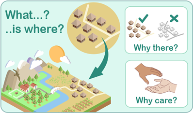
The diagram on the right is a useful and memorable model for framing geographical questions.
The course Programming for geographical inquiry K–10 explores how to ask good geographical questions.
The Inquiry learning in the HSIE KLA discussion paper read earlier in this course says:
Geographical inquiry involves posing questions, gathering data and information, analysing and interpreting data and information and reaching conclusions. A geographical inquiry assumes that the outcome of the inquiry is an action, at a scale that is relevant; personal, local, national or global.
The overarching geographical questions that drive student inquiries need to be framed so that they invite action as a response.
Consider what kinds of actions might be suitable as a response to geographical inquiries for the students you teach.
|
|
Deliverable task b: Inquiry questions Fill in the inquiry question(s) column on your implementation template for each of the inquiries and associated case studies being planned. You may need to make some modifications to the layout if you have divided or joined content headings. Formulate a main inquiry question for each inquiry. You may also like to record any additional questions that you feel may help facilitate the inquiry process. Questions in the teaching and learning frameworks may assist. |
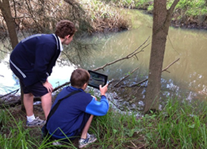
The geographical inquiry process begins with students acquiring geographical data and information.
While instructing students to ‘Just Google it!’ may sometimes be appropriate, teachers need to give considerable thought to the ways students will gather the data and information they need.
Learning experiences should be as immersive and rich as possible. An interactive online map, for example, is preferable to a classroom poster for most purposes.
Fieldwork is a mandatory component of the Geography K–10 Syllabus and should be undertaken wherever possible.
Many primary schools will connect geographical learning with work done for other key learning areas. Secondary schools may also have cross-curricular priorities to implement. Planning for the implementation of the Geography K–10 Syllabus does well to recognise these links and plan for them.
The English K–10 Syllabus, for example, states the following for students in K–6 (and similarly for Stages 4 & 5):
Across a stage of learning, the selection of texts must give students experience of:
- texts that give insights into Aboriginal experiences in Australia
- a wide range of literary texts from other countries
- texts written about intercultural experiences
- texts that provide insights about the people and cultures of Asia
- texts that include aspects of environmental and social sustainability.
Many such texts will tie in well with geography focus areas, providing rich learning experiences for students as they gather information for their case studies.
Focus area content is also tagged with learning across the curriculum content icons. These links serve as helpful prompts during the planning phase to look for connections that can be made.
|
|
Deliverable task c: Learning experiences Fill in the Learning experiences column on your implementation template. List the fieldwork, key resources and links to other key learning areas that will support student learning for each inquiry and associated case study. Consideration needs to be given to the experiences that students will have at each step of the inquiry process:
|
Geographical tools, skills and concepts
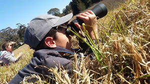
The second last column of the implementation planning template allows you to specify further details regarding each inquiry, in particular the:
-
geographical tools to be taught (K–10)
-
specific geographical inquiry skills to be developed (7–10)
-
geographical concepts at the core of this inquiry (7–10).
Note: K–6 teachers may also choose to record details regarding inquiry skills and concepts.
Students need to be supported in the development of a range of geographical tools. These tools are used for each step in the geographical inquiry process.
The processing and communicating in the inquiry process, in particular, allow students to develop skills in a range of technologies, including creating spreadsheets, websites or video.
|
|
Deliverable task d (K–6): Tools With reference to the K–10 geographical tools continuum, fill in the tools column on your implementation template. Ensure that students are exposed to a wide range of tools from each of the five categories. Once again, consider the tools to be used at each step of the inquiry process:
|
|
|
Deliverable task d (7–10): Tools/skills/concepts With reference to the K–10 geographical tools continuum, fill in the tools/skills/concepts column on your implementation template. Once again, consider the tools to be used at each step of the inquiry process:
|
Timelines
The last column of the implementation planning template allows you to indicate:
-
when during the stage cycle the inquiry will be taught
-
the duration of the inquiry.
For all stages except Early Stage 1, the teaching and learning period is two years. There is no necessity that all the inquiries for a focus area are completed in one year.
This part of your planning may require the completion of implementation plans for the other focus area(s) for the stage in question. Attention will also need to be paid to relevant scope and sequence documents.
|
|
Deliverable task e: When Fill in the When column on your implementation template if the requisite information is available. Note: Completion of the final column is not essential before submitting the deliverable in light of the dependencies involved. |


